File:Checkerboard Forest In Idaho.jpg
Die grond wat hier gewys word, word tans vir wild en bosbou aangewend. Die wit kolle weerspieël gebiede met jonger, kleiner bome, waar wintersneeubedekking helder vir die ruimtevaarders vertoon. Donker groenbruin blokkies is lappies van digter, ongeskonde woud. Die skaakbord-benadering handhaaf die volhoubaarheid van beboste streke, terwyl die oes van bome 'n opsie bly.
Die Priestrivier, wat van bo na onder deur die toneel kronkel, word weerskante deur 'n woudbuffer begrens wat as 'n natuurlike filtrasiestelsel kan dien om waterkwaliteit te beskerm. Byna 'n eeu lank is die rivier benut om hout te vervoer. Dit het egter in 1968 verander toe die rivier se hoofstroom by 'n lys van "wilde en natuurskoon riviere" gevoeg is om vir hul "uitstaande natuurlike, kulturele en ontspanningsvoordele" in 'n natuurlik-funksionerende toestand vir die genot van huidige en toekomstige geslagte bewaar te word.
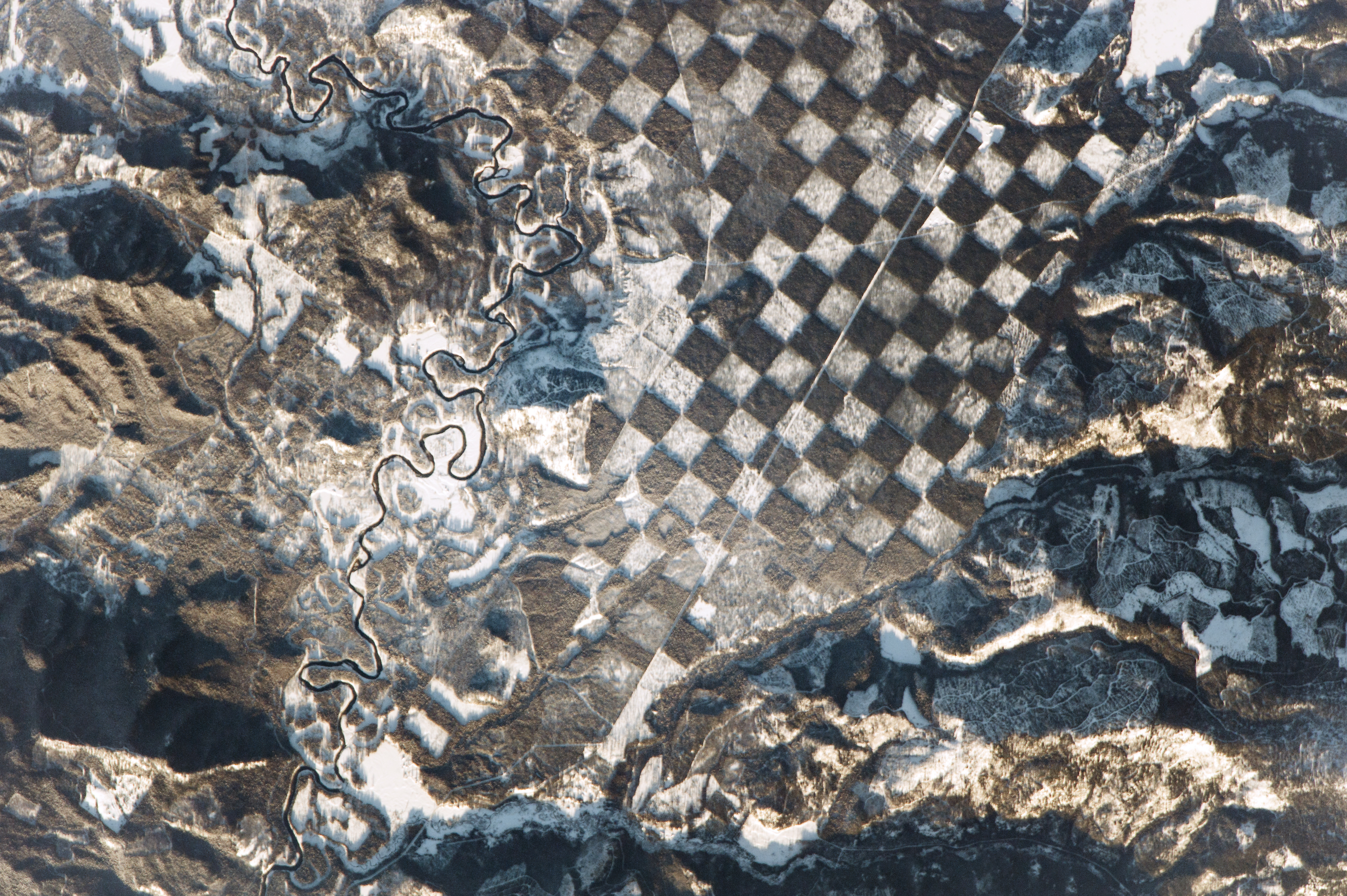
Whitetail Butte (links op beeld) is histories deur staats- en federale grondbestuurders as 'n uitkykpunt vir bosbrande gebruik.The quarter-mile (400 m) squares in this landscape checkerboard appear to be the result of forest management. Similar patterns originated in the 1800s, when alternate parcels of land were granted by the U.S. government to railroads such as the Northern Pacific. Many parcels in the Pacific Northwest were later sold off and harvested for timber.
The land shown here is now managed for wildlife and for timber harvesting. The white patches reflect areas with younger, smaller trees, where winter snow cover shows up brightly to the astronauts. Dark green-brown squares are parcels of denser, intact forest. The checkerboard is used as a method of maintaining the sustainability of forested tracts while still enabling a harvest of trees.
The Priest River, winding through the scene from top to bottom, is bordered on both sides by a forest buffer that can serve as a natural filtration system to protect water quality. For nearly a century, the river was used to transport logs. Its function changed in 1968 when the river’s main stem was added to a list of “wild and scenic rivers” in order to preserve its “outstanding natural, cultural, and recreational values in a free-flowing condition for the enjoyment of present and future generations.”
Whitetail Butte has historically been used by state and federal land managers as a lookout point for forest fires.
