File:Colonial Africa 1913 Germany Map.svg
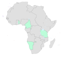
The four highlighted areas are (starting from west)
- Togoland (part of German West Africa),
- Kamerun (another discontiguous part of German West Africa),
- German Southwest Africa (now Namibia), and
- German East Africa (now Tanzania, etc).
- Colonial_Africa_1913_map.svg: Eric Gaba (Sting - fr:Sting)
- derivative work: P. S. Burton (talk)

