File:Congo Pedicle Map Showing Neighbouring Zambia.png
Click on a date/time to view the file as it appeared at that time.
| Date/Time | Thumbnail | Dimensions | User | Comment | |
|---|---|---|---|---|---|
| current | 20:41, 1 December 2017 | 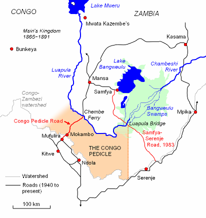 | 412 × 436 (59 KB) | Ras67 | cropped |
| 06:00, 10 February 2007 |  | 417 × 441 (58 KB) | Rexparry sydney~commonswiki | Congo Pedicle Map showing neighbouring Congo and Zambia, Luapula River, Congo-Zambezi watershed, Congo Pedicle Road, Samfya-Serenje road |
File usage
The following pages on the English Wikipedia use this file (pages on other projects are not listed):
Global file usage
The following other wikis use this file:
- Usage on be.wikipedia.org
- Usage on ca.wikipedia.org
- Usage on cs.wikipedia.org
- Usage on de.wikipedia.org
- Usage on es.wikipedia.org
- Usage on fr.wikipedia.org
- Usage on it.wikipedia.org
- Usage on ja.wikipedia.org
- Usage on ka.wikipedia.org
- Usage on ru.wikipedia.org
- Usage on sv.wikipedia.org
- Usage on tum.wikipedia.org
- Usage on uk.wikipedia.org