Click on a date/time to view the file as it appeared at that time.
| Date/Time | Thumbnail | Dimensions | User | Comment |
|---|
| current | 04:42, 8 February 2011 | 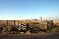 | 640 × 427 (63 KB) | GeographBot | == {{int:filedesc}} == {{Information |description={{en|1=Crown Point Road Part of The Burnley Way footpath looking towards Crown Point House}} |date=2008-02-16 |source=From [http://www.geograph.org.uk/photo/694329 geograph.org.uk] |author=[http://www.geog |
The following pages on the English Wikipedia use this file (pages on other projects are not listed):
This file contains additional information, probably added from the digital camera or scanner used to create or digitize it.
If the file has been modified from its original state, some details may not fully reflect the modified file.
