Click on a date/time to view the file as it appeared at that time.
| Date/Time | Thumbnail | Dimensions | User | Comment |
|---|
| current | 14:16, 30 January 2010 | 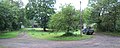 | 640 × 254 (68 KB) | GeographBot | == {{int:filedesc}} == {{Information |description={{en|1=D'Abernon Chase. This location is a clearing in Prince's Coverts, the extensive forest near Oxshott managed by the Crown Estate. It looks like it was originally used in connection with the managemen |
The following pages on the English Wikipedia use this file (pages on other projects are not listed):
This file contains additional information, probably added from the digital camera or scanner used to create or digitize it.
If the file has been modified from its original state, some details may not fully reflect the modified file.