Loading
  • 21 Aug, 2019

  • By, Wikipedia

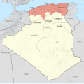
File:Départements Français D'Algérie 1934-1955 Map-fr.svg

This image is a derivative work of the following images:

  • File:French_Algeria_1934-1955_administrative_map-fr.svg licensed with Cc-by-sa-3.0,2.5,2.0,1.0, FAL
    • 2012-10-03T07:33:11Z Sémhur 1287x1278 (1817570 Bytes) 2 - With scale
    • 2012-10-02T07:17:53Z Sémhur 1287x1278 (1817568 Bytes) == {{int:filedesc}} == {{Information |Description={{Multilingual description |en= Administrative map of [[:en:French Algeria|French Algeria]] from 1905 to 1955. Three departments in the north: Alger, Constantine, Oran. Four t

Uploaded with derivativeFX
Captions

Add a one-line explanation of what this file represents

Items portrayed in this file

depicts

3 October 2012

28°19'0.1"N, 1°39'0.0"E

heading: 0 degree

File history

Click on a date/time to view the file as it appeared at that time.

Date/TimeThumbnailDimensionsUserComment
current07:14, 23 May 2014Thumbnail for version as of 07:14, 23 May 20141,287 × 1,278 (1.79 MB)SémhurValid SVG
13:22, 5 October 2012Thumbnail for version as of 13:22, 5 October 20121,287 × 1,278 (1.79 MB)Sémhur== {{int:filedesc}} == {{Information |Description={{Multilingual description |en= Administrative map of French Algeria from 1934 to 1955, showing the three "Départements français d'Algérie" (''French departments of Algeria'')...
The following pages on the English Wikipedia use this file (pages on other projects are not listed):

Global file usage

Metadata