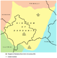
File:Dardania Kingdom.png
Main references - borders of Dardania are drawn according to the historical maps published in these books:
- Petrit Imami, Srbi i Albanci kroz vekove, Beograd, 2000.
- Dr Životije Đorđević, Kosovo i Metohija kroz vekove, Jagodina, 2009.
- https://s23.postimg.org/4gxonltsr/ilir_scan02.jpg
- https://s28.postimg.org/8irgfm3ct/ilirija_scan01.jpg
- https://s28.postimg.org/cku1egw19/regni_G.jpg
Other references that mention Dardanian kingdom / state:
- Iliri i Albanci, Beograd, 1988.
- Dragoslav Srejović, Iliri i Tračani, Beograd, 2002.
- Kosovo: the politics of identity and space By Denisa Kostovicova: https://books.google.com/books?id=L562PiBM6GEC&pg=PA139&lpg=PA139&dq=%22dardanian+state%22&source=bl&ots=Sa6Kisfj-8&sig=ZOaMq9P8ZNVjBsWnji1ful7qN34&hl=en&ei=UdNcS-P8F6PsmwPq1pSXAg&sa=X&oi=book_result&ct=result&resnum=2&ved=0CAoQ6AEwAQ
- National Identity: Who are the Albanians? The Illyrian Anthroponymy and the Ethnogenesis of the Albanians, Assoc. Prof. Vladislav B. SOTIROVIĆ, Ph.D. (European Humanities University – International & Vilnius University): http://209.85.135.132/search?q=cache:2vJChtppaokJ:www.freewebs.com/oplenac/Article%2520on%2520Illyrian-Albanian%2520ethnogenesis%2520sa%2520pozadinom.doc+%22dardanian+state%22&cd=3&hl=en&ct=clnk
Licensing
self-made map by WikiEditor2004
| I, the copyright holder of this work, release this work into the public domain. This applies worldwide. In some countries this may not be legally possible; if so: I grant anyone the right to use this work for any purpose, without any conditions, unless such conditions are required by law. |


