Loading
  • 21 Aug, 2019

  • By, Wikipedia

File:DeSoto Map Leg 3 HRoe 2008.jpg

Transferred from en.wikipedia to Commons by Heironymous Rowe.

The original description page was here. All following user names refer to en.wikipedia.
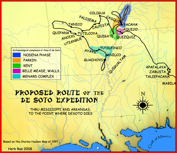
  • 2008-09-20 20:11 Heironymous Rowe 610×527× (345692 bytes) {{Information |Description=A map showing the [[Hernando de Soto|de Soto]] expedition route thru [[Mississippi]], and [[Arkansas]], up to the point de Soto dies. Based on the [[Charles M. Hudson (author)|Charles M. Hudson]] map of 1997. |Source=I created t

Captions

Add a one-line explanation of what this file represents

Items portrayed in this file

depicts

image/jpeg

345,692 byte

527 pixel

610 pixel

6b712cedc7c34ac6b165984b7b3b269d3b6fb017

File history

Click on a date/time to view the file as it appeared at that time.

Date/TimeThumbnailDimensionsUserComment
current14:51, 21 May 2009Thumbnail for version as of 14:51, 21 May 2009610 × 527 (338 KB)Heironymous Rowe{{Information |Description={{en|A map showing the de Soto expedition route thru en:Mississippi, and en:Arkansas, up to the point de Soto dies. Based on the Charles M. Hudson map of 19
14:50, 21 May 2009Thumbnail for version as of 14:50, 21 May 2009610 × 527 (338 KB)Heironymous Rowe{{Information |Description={{en|A map showing the de Soto expedition route thru en:Mississippi, and en:Arkansas, up to the point de Soto dies. Based on the Charles M. Hudson map of 19

Global file usage

Metadata