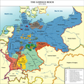
File:Deutsches Reich (1871-1918)-en.png
Deutsches_Reich1.png, itself based on:
Author
Other versions
- Putzger, F. W. (1965) Historischer Weltatlas (89 ed.)
- (1969) Westermanns Großer Atlas zur Weltgeschichte, Georg Westermann Verlag
- Haacks geographischer Atlas. VEB Hermann Haack Geographisch-Kartographische Anstalt, Gotha/Leipzig, 1. Auflage, 1979
- Kinder, Hermann (1989) Dtv-Atlas Weltgeschichte / 2, Von der Französischen Revolution bis zur Gegenwart. (23 ed.), Munich: Dt. Taschenbuch-Verl ISBN: 3-423-03002-X. OCLC: 313766861.
- Deutsches_Reich1.png: kgberger
- derivative work: Wiggy! (talk)
[]
-
 Deutsch
 -
 Deutsch (original)
 -
 English (original)
 -
 español
 -
 Esperanto
 -
 فارسی
فارسی -
 français
 -
 Bahasa Melayu
 -
 occitan
 -
 العربية
 -
 עברית
עברית -
 Türkçe

-de.svg)
-en.png)
-es.svg)
-eo.svg)
-fa.svg)
-fr.svg)
-ms.svg)
-oc.png)
-ar.svg)
-he.svg)
-tr.svg)
| This is a retouched picture, which means that it has been digitally altered from its original version. Modifications: Anglicize place names. The original can be viewed here: Deutsches Reich1.png:
|
I, the copyright holder of this work, hereby publish it under the following licenses:
This file is licensed under the Creative Commons Attribution-Share Alike 2.5 Generic, 2.0 Generic and 1.0 Generic license.
- You are free:
- to share – to copy, distribute and transmit the work
- to remix – to adapt the work
- Under the following conditions:
- attribution – You must give appropriate credit, provide a link to the license, and indicate if changes were made. You may do so in any reasonable manner, but not in any way that suggests the licensor endorses you or your use.
- share alike – If you remix, transform, or build upon the material, you must distribute your contributions under the same or compatible license as the original.

|
Permission is granted to copy, distribute and/or modify this document under the terms of the GNU Free Documentation License, Version 1.2 or any later version published by the Free Software Foundation; with no Invariant Sections, no Front-Cover Texts, and no Back-Cover Texts. A copy of the license is included in the section entitled GNU Free Documentation License. |
| This file is licensed under the Creative Commons Attribution-Share Alike 3.0 Unported license. | ||
| ||
| This licensing tag was added to this file as part of the GFDL licensing update. |
You may select the license of your choice.
Original upload log
This image is a derivative work of the following images:
- File:Deutsches_Reich1.png licensed with Cc-by-sa-2.5,2.0,1.0, GFDL
- 2008-12-16T16:23:16Z Ziegelbrenner 2362x2362 (2258142 Bytes) {{Information |Description= |Source= |Date= |Author= |Permission= |other_versions={{DerivativeVersions|German Empire 18711918.png}} }}
- 2008-12-11T11:27:03Z Ziegelbrenner 2362x2362 (2260380 Bytes) {{Information |Description= |Source= |Date= |Author= |Permission= |other_versions={{DerivativeVersions|German Empire 18711918.png}} }}
- 2008-07-01T14:14:11Z Ziegelbrenner 2354x2362 (2258142 Bytes) {{Information |Description= |Source= |Date= |Author= |Permission= |other_versions={{DerivativeVersions|German Empire 18711918.png}} }}
- 2008-01-21T09:34:51Z Ziegelbrenner 3236x3248 (1665678 Bytes)
- 2007-12-13T09:42:02Z Ziegelbrenner 3236x3248 (2069252 Bytes)
- 2007-12-12T10:21:15Z Ziegelbrenner 3236x3248 (1085706 Bytes)
- 2007-12-11T17:47:41Z Ziegelbrenner 3236x3248 (1085706 Bytes)
- 2007-12-11T17:46:22Z Ziegelbrenner 3236x3248 (1085706 Bytes)
- 2007-11-29T15:31:15Z Ziegelbrenner 3236x3248 (1977671 Bytes)
- 2007-11-29T15:27:21Z Ziegelbrenner 3236x3248 (1977772 Bytes)
- 2007-11-29T15:26:32Z Ziegelbrenner 3236x3248 (1638016 Bytes) Reverted to version as of 12:13, 8 October 2007
- 2007-11-29T15:26:01Z Ziegelbrenner 3236x3248 (1977772 Bytes)
- 2007-10-08T12:13:37Z Ziegelbrenner 3236x3248 (1638016 Bytes)
- 2007-10-05T10:21:47Z Ziegelbrenner 3236x3248 (1639587 Bytes)
- 2007-08-30T12:00:13Z Ziegelbrenner 3240x3253 (1068230 Bytes)
- 2007-07-19T11:02:58Z Ziegelbrenner 3240x3188 (5281730 Bytes)
- 2007-03-09T13:23:23Z Ziegelbrenner 3239x3188 (3435784 Bytes)
- 2007-02-16T13:23:10Z Ziegelbrenner 3240x3188 (3432764 Bytes)
- 2007-02-08T11:34:44Z Ziegelbrenner 3239x3187 (3358555 Bytes)
- 2007-02-01T15:22:17Z Ziegelbrenner 3238x3188 (3348717 Bytes)
- 2006-12-22T15:04:06Z Ziegelbrenner 3239x3187 (3350040 Bytes)
- 2006-12-19T13:37:27Z Ziegelbrenner 3239x3186 (3342936 Bytes)
- 2006-12-11T16:44:19Z Ziegelbrenner 3238x3186 (3313706 Bytes)
- 2006-11-30T16:05:29Z Ziegelbrenner 3239x3185 (4812520 Bytes)
- 2006-11-20T17:34:36Z Ziegelbrenner 3239x3185 (3242737 Bytes)
- 2006-11-20T17:04:01Z Ziegelbrenner 3238x3184 (3248550 Bytes)
- 2006-10-06T11:34:17Z Ziegelbrenner 3241x3187 (4867783 Bytes)
- 2006-09-21T14:19:37Z Ziegelbrenner 3238x3226 (4843000 Bytes) == Summary == * Description: Karte des »Deutschen Reiches« 1871–1918 / Map of »German Reich« 1871–1918 * Source of information: Putzger – Historischer Weltatlas, 89. Auflage, 1965 * Author: [[:de:Benutzer:kgberger|
Uploaded with derivativeFX

-en.png)
-en.png)