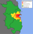
File:Dublin City Boundaries 2020.png
Click on a date/time to view the file as it appeared at that time.
| Date/Time | Thumbnail | Dimensions | User | Comment | |
|---|---|---|---|---|---|
| current | 13:30, 6 July 2022 |  | 2,552 × 2,480 (484 KB) | Jacobfrid | Update boundaries to reflect more accurate Dublin SPA Socio-Economic Evidence Baseline Report, Nov 2017 version of the DMA |
| 10:49, 29 September 2020 |  | 2,552 × 2,480 (487 KB) | Jacobfrid | Reverted to version as of 09:17, 29 September 2020 (UTC) | |
| 10:49, 29 September 2020 |  | 2,552 × 2,480 (486 KB) | Jacobfrid | re | |
| 09:17, 29 September 2020 |  | 2,552 × 2,480 (487 KB) | Jacobfrid | Remove green area in Dublin city | |
| 07:10, 18 July 2020 |  | 2,552 × 2,480 (385 KB) | Jacobfrid | Change overlay order to show Kildare / Meath county boundaries over DMA boundary | |
| 16:23, 17 July 2020 |  | 2,408 × 2,476 (366 KB) | Jacobfrid | Uploaded own work with UploadWizard |
File usage
The following 2 pages use this file: