Click on a date/time to view the file as it appeared at that time.
| Date/Time | Thumbnail | Dimensions | User | Comment |
|---|
| current | 12:28, 7 February 2011 | 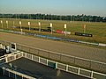 | 640 × 480 (81 KB) | GeographBot | == {{int:filedesc}} == {{Information |description={{en|1=Dunstall Park racecourse, Wolverhampton Beyond the all weather race track is a trotting track. The trees beyond are along the line of the Staffordshire and Worcestershire Canal. Seen from the grands |
The following page uses this file:
This file contains additional information, probably added from the digital camera or scanner used to create or digitize it.
If the file has been modified from its original state, some details may not fully reflect the modified file.
