File:East-tennessee-landforms.png
Click on a date/time to view the file as it appeared at that time.
| Date/Time | Thumbnail | Dimensions | User | Comment | |
|---|---|---|---|---|---|
| current | 21:57, 18 August 2009 | 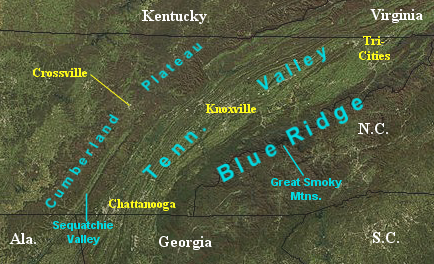 | 434 × 264 (238 KB) | BrineStans | {{Information |Description=Satellite image showing the major topographical features of East Tennessee. |Source=[http://rapidfire.sci.gsfc.nasa.gov/gallery/ NASA MODIS Rapid Response System |Date=2004-12 (image); 2009-08 (annotation) |Author=NASA (image) |
File usage
The following page uses this file:
Global file usage
The following other wikis use this file:
- Usage on zh.wikipedia.org