Click on a date/time to view the file as it appeared at that time.
| Date/Time | Thumbnail | Dimensions | User | Comment |
|---|
| current | 05:31, 14 December 2011 | 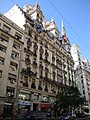 | 1,536 × 2,048 (556 KB) | Rotatebot | Bot: Image rotated by 270° (EXIF-Orientation set from 6 to 1, rotated 0°) |
| 15:09, 28 March 2010 |  | 2,048 × 1,536 (556 KB) | Elsapucai | {{Information |Description={{es|1=Vista desde la Avenida Córdoba hacia el este del edificio de departamentos proyectado por Eduardo Le Monnier para la constructora Bencich Hermanos en 1927. Está en la esquina de la Avenida Córdoba y la calle Esmeralda. |
The following pages on the English Wikipedia use this file (pages on other projects are not listed):
The following other wikis use this file:
- Usage on ast.wikipedia.org
- Usage on es.wikipedia.org
- Usage on sv.wikipedia.org
- Usage on zh.wikipedia.org
This file contains additional information, probably added from the digital camera or scanner used to create or digitize it.
If the file has been modified from its original state, some details may not fully reflect the modified file.


.JPG¶ms=-34.598992_N_-058.379061_E_globe:Earth_type:camera_region:AR_heading:45.00&language=en)
.JPG)