Loading
  • 21 Aug, 2019

  • By, Wikipedia

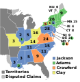
File:ElectoralCollege1824.svg

1788-1789 · 1792 · 1796 · 1800 · 1804 · 1808 · 1812 · 1816 · 1820 · 1824 · 1828 · 1832 · 1836 · 1840 · 1844 · 1848 · 1852 · 1856 · 1860 · 1864 · 1868 · 1872 · 1876 · 1880 · 1884 · 1888 · 1892 · 1896 · 1900 · 1904 · 1908 · 1912 · 1916 · 1920 · 1924 · 1928 · 1932 · 1936 · 1940 · 1944 · 1948 · 1952 · 1956 · 1960 · 1964 · 1968 · 1972 · 1976 · 1980 · 1984 · 1988 · 1992 · 1996 · 2000 · 2004 · 2008 · 2012 · 2016 · 2020 · 2024

(this template: · view · discuss)


Summary

Description
English: 1824 Electoral College
Date Unknown date
Source Own work
Author AndyHogan14
SVG development
InfoField
 
W3C-validity not checked.

Licensing

Public domain I, the copyright holder of this work, release this work into the public domain. This applies worldwide.
In some countries this may not be legally possible; if so:
I grant anyone the right to use this work for any purpose, without any conditions, unless such conditions are required by law.

Captions

Map of the Presidential Election of 1824 between Andrew Jackson, John Quincy Adams, William H. Crawford, and Henry Clay

Items portrayed in this file

depicts

image/svg+xml

File history

Click on a date/time to view the file as it appeared at that time.

(newest | oldest) View (newer 10 | ) (10 | 20 | 50 | 100 | 250 | 500)
Date/TimeThumbnailDimensionsUserComment
current00:33, 18 June 2023Thumbnail for version as of 00:33, 18 June 2023577 × 593 (190 KB)Rogl94Corrected Delaware and Maine
22:34, 11 July 2018Thumbnail for version as of 22:34, 11 July 2018577 × 593 (193 KB)Wowfix
21:49, 11 July 2018Thumbnail for version as of 21:49, 11 July 2018577 × 593 (193 KB)Wowdisputed claim
02:22, 27 December 2016Thumbnail for version as of 02:22, 27 December 2016577 × 593 (112 KB)WowAdams
06:57, 14 November 2016Thumbnail for version as of 06:57, 14 November 2016577 × 593 (112 KB)WowClay's states
06:54, 14 November 2016Thumbnail for version as of 06:54, 14 November 2016577 × 593 (112 KB)WowTerritories
22:55, 31 July 2016Thumbnail for version as of 22:55, 31 July 2016577 × 593 (112 KB)Spartan7Wno need for entire continent when no states are further west than Missouri
09:47, 18 October 2011Thumbnail for version as of 09:47, 18 October 20111,020 × 593 (45 KB)Fred the Oysteroptimise and try to correct render artifact
01:56, 1 January 2009Thumbnail for version as of 01:56, 1 January 20091,020 × 593 (97 KB)AndyHogan14{{Information |Description= |Source= |Date= |Author= |Permission= |other_versions= }}
19:54, 31 December 2008Thumbnail for version as of 19:54, 31 December 20081,020 × 593 (97 KB)AndyHogan14{{Information |Description= |Source= |Date= |Author= |Permission= |other_versions= }}
(newest | oldest) View (newer 10 | ) (10 | 20 | 50 | 100 | 250 | 500)

The following 50 pages use this file:

Global file usage

The following other wikis use this file:

Metadata