Loading
  • 21 Aug, 2019

  • By, Wikipedia

File:Empire Of Theodoric The Great 523.gif

Transferred from en.wikipedia to Commons by Lazyhawk using CommonsHelper.

The original description page was here. All following user names refer to en.wikipedia.
  • 2007-12-28 04:23 Vortimer 523×478× (33298 bytes) {{Information |Description=Map of the territories (pink) ruled by Theodoric the Great at their height in 523, when he annexed the souther part of the Burgundian kingdom, between the rivers Durance and Isere. Stippled areas indicate other kin
  • 2007-12-27 12:01 Vortimer 523×478× (33484 bytes) {{Information |Description=Map of the territories (pink) ruled by Theodoric the Great at their height in 523, when he annexed the souther part of the Burgundian kingdom, between the rivers Durance and Isere. Stippled areas indicate other kingdoms dominate
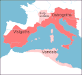
  • 2007-12-27 11:57 Vortimer 523×478× (32320 bytes) {{Information |Description=Map of the territories (pink) ruled by Theodoric the Great at their height in 523, when he annexed the souther part of the Burgundian kingdom, between the rivers Durance and Isere. Stippled areas indicate other kingdoms dominate

Captions

Add a one-line explanation of what this file represents

Items portrayed in this file

depicts

27 December 2007

File history

Click on a date/time to view the file as it appeared at that time.

Date/TimeThumbnailDimensionsUserComment
current13:15, 20 December 2011Thumbnail for version as of 13:15, 20 December 2011523 × 478 (33 KB)OgreBot(BOT): Reverting to most recent version before archival
13:15, 20 December 2011Thumbnail for version as of 13:15, 20 December 2011523 × 478 (33 KB)OgreBot(BOT): Uploading old version of file from en.wikipedia; originally uploaded on 2007-12-27 12:01:51 by Vortimer
13:15, 20 December 2011Thumbnail for version as of 13:15, 20 December 2011523 × 478 (32 KB)OgreBot(BOT): Uploading old version of file from en.wikipedia; originally uploaded on 2007-12-27 11:57:01 by Vortimer
01:55, 12 September 2011Thumbnail for version as of 01:55, 12 September 2011523 × 478 (33 KB)File Upload Bot (Magnus Manske) {{BotMoveToCommons|en.wikipedia|year={{subst:CURRENTYEAR}}|month={{subst:CURRENTMONTHNAME}}|day={{subst:CURRENTDAY}}}} {{Information |Description={{en|Map of the territories (pink) ruled by Theodoric the Great at their height in 523, when he annexed the
The following pages on the English Wikipedia use this file (pages on other projects are not listed):

Global file usage

The following other wikis use this file: