File:Ethnic Map Of Hungary 1910 With Counties.png
Click on a date/time to view the file as it appeared at that time.
| Date/Time | Thumbnail | Dimensions | User | Comment | |
|---|---|---|---|---|---|
| current | 13:29, 22 September 2023 | 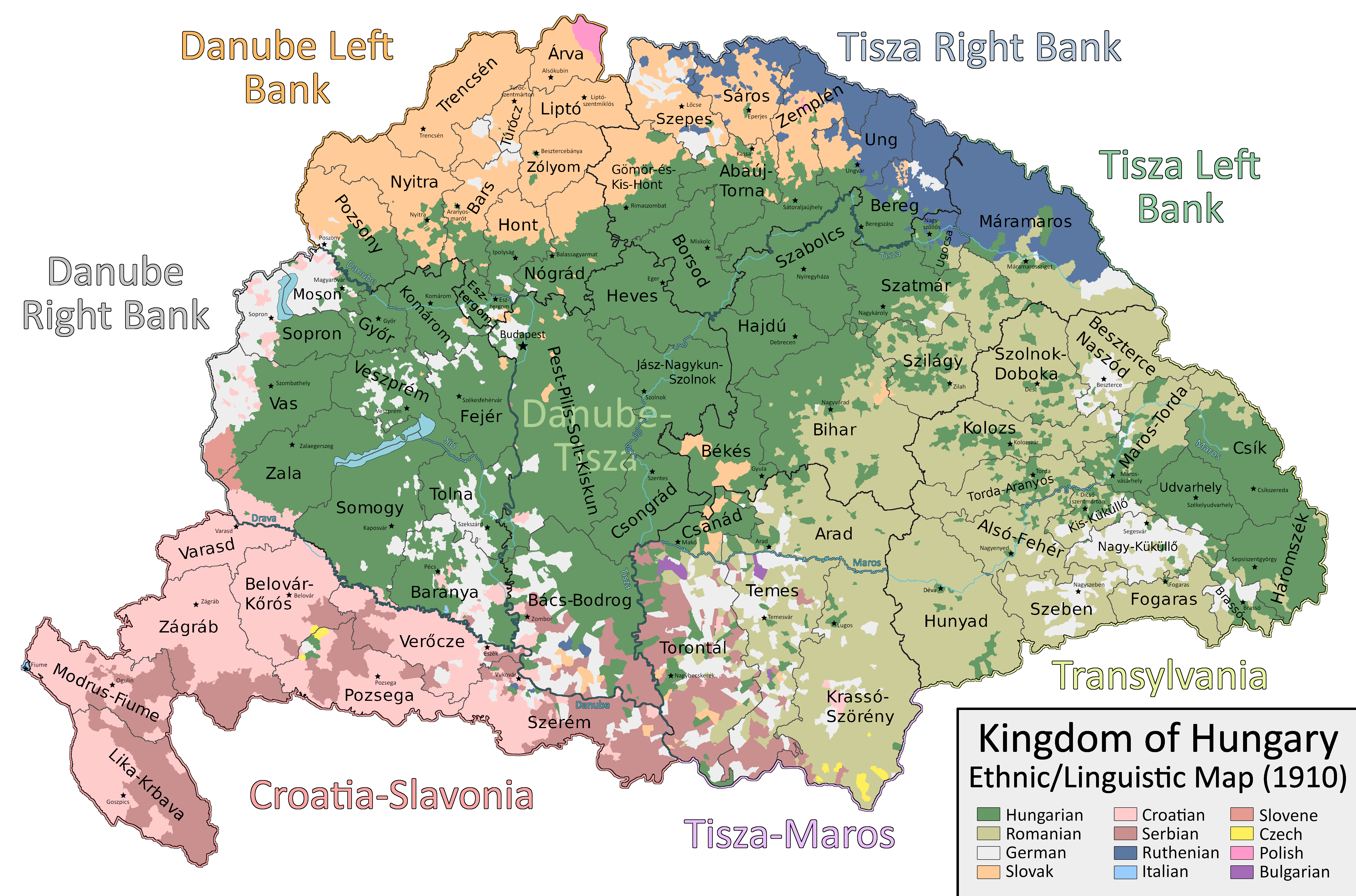 | 6,208 × 4,104 (1.41 MB) | Ascended Dreamer | Change color of Slovene |
| 15:00, 22 July 2023 |  | 6,208 × 4,104 (1.41 MB) | Ascended Dreamer | Correcting more errors noticed by Alphathon | |
| 21:26, 19 July 2023 |  | 6,208 × 4,104 (1.41 MB) | Ascended Dreamer | Incorporating Corrections made by Alpathon | |
| 08:40, 19 July 2023 |  | 6,208 × 4,104 (1.34 MB) | Alphathon | Applied (rough) corrections to Bars/Hont and Csongrád/Bács-Bodrog borders | |
| 23:02, 1 July 2023 |  | 6,208 × 4,104 (1.41 MB) | Ascended Dreamer | Corrected location of Nagykároly | |
| 20:02, 27 April 2023 |  | 6,208 × 4,104 (1.41 MB) | Ascended Dreamer | Corrected color indicating Slovenes | |
| 01:18, 21 January 2023 |  | 6,208 × 4,104 (1.41 MB) | Ascended Dreamer | Changed color of lakes to blue | |
| 22:33, 20 January 2023 |  | 6,208 × 4,104 (1.41 MB) | Ascended Dreamer | Increased border accuracy | |
| 03:26, 16 January 2023 |  | 6,208 × 4,104 (1.19 MB) | Ascended Dreamer | Added county capital names | |
| 20:44, 15 January 2023 |  | 6,208 × 4,104 (975 KB) | Ascended Dreamer | Cleaned up map, fixed error, added small stars indicating county capital locations. Better to leave them unlabeled? |
File usage
The following pages on the English Wikipedia use this file (pages on other projects are not listed):
Global file usage
The following other wikis use this file:
- Usage on ca.wikipedia.org
- Usage on hu.wikipedia.org
- Usage on pt.wikipedia.org
- Usage on sk.wikipedia.org
- Usage on sr.wikipedia.org
- Usage on tr.wikipedia.org