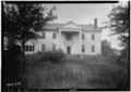
File:FRONT ELEVATION - Weston (House And Schoolhouse), U.S. Route 11 And County Road 19 Vicinity, Boligee, Greene County, AL HABS ALA,32-BOLI.V,2-1.tif
This tag does not indicate the copyright status of the attached work. A normal copyright tag is still required. See Commons:Licensing.
Notes
Source
https://www.loc.gov/pictures/item/al0175.photos.002284p
Permission
(Reusing this file)
- Survey number: HABS AL-272
- Building/structure dates: ca. 1836 Initial Construction
(Reusing this file)
| This image or media file contains material based on a work of a National Park Service employee, created as part of that person's official duties. As a work of the U.S. federal government, such work is in the public domain in the United States. See the NPS website and NPS copyright policy for more information. |
| Object location | | View this and other nearby images on: OpenStreetMap |
|---|