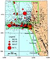
File:Ferndale Eureka RegionHistoricSeismicity.jpg

| Camera location | | View this and other nearby images on: OpenStreetMap |
|---|

| Camera location | | View this and other nearby images on: OpenStreetMap |
|---|
Click on a date/time to view the file as it appeared at that time.
| Date/Time | Thumbnail | Dimensions | User | Comment | |
|---|---|---|---|---|---|
| current | 02:08, 11 December 2011 |  | 496 × 590 (355 KB) | Ellin Beltz | {{Information |Description ={{en|1=Dots are from 1985-2003 earthquakes with magnitude greater than 2 near Eureka and Ferndale in northern California. Major roads in white; known active faults in brown. Green boxes refer to active plate interations G |
The following 2 pages use this file:
The following other wikis use this file: