File:Fladen Light.PNG
Please see Category:Image cleanup templates for templates used to mark images that only need a clean-up. For more help, see Commons:Media for cleanup#Low quality images.
Summary
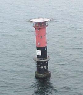
| Description |
English: Fladen light, (57°13'N., 11°50'E.), equipped with a racon, is shown from a prominent floodlit tower, 26m high, standing on the NE side of Fladen, a sand bank with a least depth of 5.9 meters in teh Kattegat |
| Date | |
| Source | http://www.nga.mil/portal/site/maritime/?epi_menuItemID=eb128c56b8e903e25b2a7fbd3227a759&epi_menuID=35ad5b8aabcefa1a0fc133443927a759&epi_baseMenuID=e106a3b5e50edce1fec24fd73927a759 Sailing Directions Enroute, Vol. 193, page 95 |
| Author | NGA |
Licensing
This image is a work of the United States National Geospatial-Intelligence Agency or one of its predecessor agencies. As a work of the U.S. federal government, the image is in the public domain.
|
 |