Click on a date/time to view the file as it appeared at that time.
| Date/Time | Thumbnail | Dimensions | User | Comment |
|---|
| current | 22:25, 30 January 2010 | 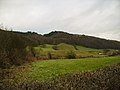 | 640 × 480 (106 KB) | GeographBot | == {{int:filedesc}} == {{Information |description={{en|1=Flodden Hill Wood. Along the ridge of Lythe Brow Wood taken from Quernmore Road, the buildings of Lythe Brow visible. Near to this spot in close proximity are a Prehistoric Hill Fort at Askew Hill F |
The following 2 pages use this file:
This file contains additional information, probably added from the digital camera or scanner used to create or digitize it.
If the file has been modified from its original state, some details may not fully reflect the modified file.
