Click on a date/time to view the file as it appeared at that time.
| Date/Time | Thumbnail | Dimensions | User | Comment |
|---|
| current | 02:40, 7 March 2010 | 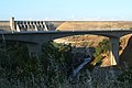 | 3,504 × 2,336 (4.05 MB) | Life of Riley | {{Information |description ={{en|The new Folsom Lake Crossing bridge over the American River below Folsom Dam. The bridge was opened in March 2009.}} |date =2009-06-19 |source =U.S. Army Corps of Engineers photo ID 090619-A-3200N-003< |
The following page uses this file:
This file contains additional information, probably added from the digital camera or scanner used to create or digitize it.
If the file has been modified from its original state, some details may not fully reflect the modified file.
