Click on a date/time to view the file as it appeared at that time.
| Date/Time | Thumbnail | Dimensions | User | Comment |
|---|
| current | 04:59, 24 July 2010 | 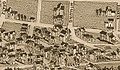 | 640 × 375 (74 KB) | BrineStans | {{Information |Description={{en|1=Detail of an 1886 map of Knoxville, Tennessee, showing the Fourth and Gill neighborhood. "McClung" is now Luttrell Street. }} |Source=[http://hdl.loc.gov/loc.gmd/g3964k.pm009000 Library of Congress - Geography and Maps |
The following page uses this file:
This file contains additional information, probably added from the digital camera or scanner used to create or digitize it.
If the file has been modified from its original state, some details may not fully reflect the modified file.


