Loading
  • 21 Aug, 2019

  • By, Wikipedia

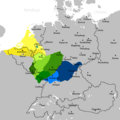
File:Fränkisches Sprachgebiet.png

Low Franconian
 
North Low Franconian (incl. Dutch, Kleverlandish, East Bergish)
 
South Low Franconian (incl. Limburgish)
Central Franconian (West Central German and hence Central German)
 
Luxembourgish (Moselle Franconian)
Rhine Franconian (West Central German)
High Franconian (between Central and Upper German)
 
East Franconian (spoken in Franconia)
Date Source Own work Author Andre Exeler / Imperator24 Permission
(Reusing this file)
This work has been released into the public domain by its author, Andre3004, at the English Wikipedia project. This applies worldwide.

In case this is not legally possible:
Andre3004 grants anyone the right to use this work for any purpose, without any conditions, unless such conditions are required by law.

Other versions File:Die Frankiese taalgebied.png

Captions

The Franconian dialects

Items portrayed in this file

depicts

30 November 2009

image/png

File history

Click on a date/time to view the file as it appeared at that time.

Date/TimeThumbnailDimensionsUserComment
current01:28, 11 January 2020Thumbnail for version as of 01:28, 11 January 2020652 × 652 (29 KB)SpazzoDuisburg and Kleve added Position of Cologne corrected
14:20, 30 November 2009Thumbnail for version as of 14:20, 30 November 2009652 × 652 (32 KB)Imperator24{{Information |Description={{de|1=kleinere Ausbesserungen}} |Source={{own}} |Author=Imperator24 |Date=30.11.2009 |Permission= |other_versions=Die Frankiese taalgebied.png }}

The following page uses this file:

Global file usage

The following other wikis use this file:

Metadata