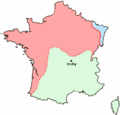
File:France Zonelibre Blank.PNG
Click on a date/time to view the file as it appeared at that time.
| Date/Time | Thumbnail | Dimensions | User | Comment | |
|---|---|---|---|---|---|
| current | 15:34, 3 July 2006 |  | 431 × 413 (11 KB) | Roke~commonswiki | {{Information |Description= Map showing German occupied France (red), Vichy France (green), area annexed by Germany (blue), during the Second World War (1940-44) |Source= Blank version of french map |Date= july 2006 |Author= User:Fabien1309's map | |
File usage
The following page uses this file:
Global file usage
The following other wikis use this file:
- Usage on fr.wikipedia.org
- Usage on id.wikipedia.org