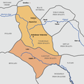
File:Galicia-Volhynia Map.PNG
Click on a date/time to view the file as it appeared at that time.
| Date/Time | Thumbnail | Dimensions | User | Comment | |
|---|---|---|---|---|---|
| current | 13:48, 20 November 2017 |  | 661 × 655 (41 KB) | Mélomène | The same, based also on german historic atlases (H.E. Stier's Grosser Atlas zur Weltgeschichte, Westermann 1985, ISBN 3-14-100919-8, p. 71) |
| 23:24, 18 February 2009 |  | 661 × 655 (31 KB) | Mahahahaneapneap | Compressed | |
| 00:16, 14 February 2007 |  | 661 × 655 (42 KB) | Kpalion | Map of Galicia-Volhynia, ca. 13 century Based on the Belarusian version uploaded by Alexander Gouk. |
File usage
The following 5 pages use this file:
Global file usage
The following other wikis use this file:
- Usage on azb.wikipedia.org
- Usage on be.wikipedia.org
- Usage on ca.wikipedia.org
- Usage on ckb.wikipedia.org
- Usage on cs.wikipedia.org
- Usage on de.wikipedia.org
- Usage on et.wikipedia.org
- Usage on fr.wikipedia.org
- Usage on it.wikipedia.org
- Usage on ja.wikipedia.org
- Usage on ko.wikipedia.org
- Usage on lt.wikipedia.org
- Usage on lv.wikipedia.org
- Usage on sl.wikipedia.org
- Usage on sr.wikipedia.org
- Usage on ta.wikipedia.org
- Usage on tg.wikipedia.org
- Usage on tr.wikipedia.org
- Usage on uk.wikipedia.org
- Usage on vi.wikipedia.org