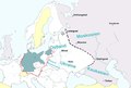
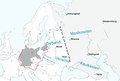
File:Generalplan Ost Map.tiff
Legend:
Blue-green – Germany (Deutsches Reich).
Dotted black line – the extension of detailed plans of a second ”phase of settlement” (Siedlungsphase).
Light grey – the greatest extension of Generalplan Ost.
The names in blue – Nazi regions called Reichskommissariat : Ostland (1941-1945), Ukraine (1941-1945), Moskowien (never realized), Kaukasien (never realized).
Yellow – neutral countries.
The map is based on texts and graphics on Deutsche Forschungsgemeinschaft: Der Generalplan Ost der Nationalsozialisten, [1]
(Reusing this file)
| I, the copyright holder of this work, release this work into the public domain. This applies worldwide. In some countries this may not be legally possible; if so: I grant anyone the right to use this work for any purpose, without any conditions, unless such conditions are required by law. |