File:Grand Portage Route.JPG
Bahasa Indonesia ∙ català ∙ čeština ∙ Deutsch ∙ eesti ∙ English ∙ español ∙ français ∙ galego ∙ italiano ∙ Nederlands ∙ português ∙ polski ∙ sicilianu ∙ suomi ∙ Tiếng Việt ∙ Türkçe ∙ български ∙ македонски ∙ русский ∙ മലയാളം ∙ 한국어 ∙ 日本語 ∙ 中文 ∙ 中文(简体) ∙ 中文(繁體) ∙ العربية ∙ فارسی ∙ +/−
Original upload log
The original description page was
here . All following user names refer to en.wikipedia.
Date/Time
Dimensions
User
Comment
2010-03-05 23:35
629×561× (75472 bytes)
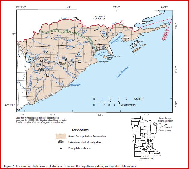
Bettymnz4 {{Information |Description ="""English:'''Grand Portage National Monument, Minnesota, map, in Northeastern Minnesota; prepared by the Minnesota Geological Survey and used by the USGS in, "Ground-Water/Surface-Water Interaction in Nearshore Areas of Th
English Add a one-line explanation of what this file represents
File history
Click on a date/time to view the file as it appeared at that time.
Date/Time Thumbnail Dimensions User Comment current 04:19, 17 August 2015 629 × 561 (74 KB) Innotata Transferred from en.wikipedia
File usage
The following pages on the English Wikipedia use this file (pages on other projects are not listed):
Global file usage
The following other wikis use this file:
Usage on ru.wikipedia.org
This file contains additional information, probably added from the digital camera or scanner used to create or digitize it.
If the file has been modified from its original state, some details may not fully reflect the modified file.