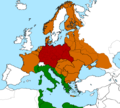
File:Greater German Reich In 1942.png
Click on a date/time to view the file as it appeared at that time.
| Date/Time | Thumbnail | Dimensions | User | Comment | |
|---|---|---|---|---|---|
| current | 20:14, 6 May 2018 |  | 1,829 × 1,647 (104 KB) | Spesh531 | Fixing borders, which were slightly bolder |
| 20:09, 6 May 2018 |  | 1,829 × 1,647 (107 KB) | Spesh531 | Beligum-Northern France is one unit | |
| 19:36, 6 May 2018 |  | 1,829 × 1,647 (104 KB) | Spesh531 | Updating borders, better resolution | |
| 06:00, 3 February 2010 |  | 665 × 599 (227 KB) | Petr Losert | {{Information |Description={{en|1=Map of the Greater German Reich in 1942.}} {{cs|1=Mapa Německé říše k roku 1942.}} |Source=http://en.wikipedia.org/key/File:Greater_German_Reich_in_1942.png |Author=Mackay 86 |Date= |Permission={{self|cc-by-sa-3.0|G |
File usage
The following 8 pages use this file:
Global file usage
The following other wikis use this file:
- Usage on ar.wikipedia.org
- Usage on it.wikipedia.org
- Usage on ja.wikipedia.org
- Usage on ko.wikipedia.org
- Usage on krc.wikipedia.org
- Usage on no.wikipedia.org
- Usage on os.wikipedia.org
- Usage on zh.wikipedia.org