File:Grove City Aerial Shot 2024-06-15 2.jpg
http://creativecommons.org/publicdomain/zero/1.0/deed.enCC0Creative Commons Zero, Public Domain Dedicationfalsefalse
Aerial photographs of Grove City, Pennsylvania, from ~2000 ft above the ground
Click on a date/time to view the file as it appeared at that time.
| Date/Time | Thumbnail | Dimensions | User | Comment |
|---|
| current | 01:58, 16 June 2024 | 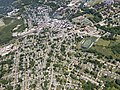 | 4,032 × 3,024 (5.4 MB) | 痛 | Uploaded own work with UploadWizard |
The following pages on the English Wikipedia use this file (pages on other projects are not listed):
This file contains additional information, probably added from the digital camera or scanner used to create or digitize it.
If the file has been modified from its original state, some details may not fully reflect the modified file.
