Click on a date/time to view the file as it appeared at that time.
| Date/Time | Thumbnail | Dimensions | User | Comment |
|---|
| current | 08:49, 18 December 2008 | 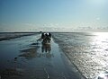 | 2,520 × 1,854 (2.24 MB) | Smial | Horizont ohne Treppen |
| 12:47, 13 October 2008 | 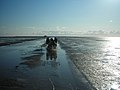 | 2,445 × 1,842 (3.01 MB) | Ulamm | {{Information |Description=Horse cart in the Wattenmeer (German foreshore) near the small island of Südfall. |Source=photo de:Image:Hallig_Suedfall.JPGby Obelix |Date=2008-10-13 |Author=photo by Obelix |
The following 2 pages use this file:
The following other wikis use this file:
- Usage on ar.wikipedia.org
- Usage on ceb.wikipedia.org
- Usage on da.wikipedia.org
- Usage on de.wikipedia.org
- Usage on eo.wikipedia.org
- Usage on es.wikipedia.org
- Usage on frr.wikipedia.org
- Usage on fr.wikipedia.org
- Usage on fy.wikipedia.org
- Usage on ka.wikipedia.org
- Usage on mk.wikipedia.org
- Usage on ms.wikipedia.org
- Usage on nl.wikipedia.org
- Usage on pnb.wikipedia.org
- Usage on ru.wikipedia.org
- Usage on vi.wikipedia.org
This file contains additional information, probably added from the digital camera or scanner used to create or digitize it.
If the file has been modified from its original state, some details may not fully reflect the modified file.

