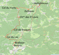
File:Hantzbahn - Superimposed Onto OpenStreetMap Map.png
Click on a date/time to view the file as it appeared at that time.
| Date/Time | Thumbnail | Dimensions | User | Comment | |
|---|---|---|---|---|---|
| current | 11:10, 14 September 2020 |  | 971 × 907 (912 KB) | NearEMPTiness | Version 2.1 (without crossing the border at Col du Las) |
| 10:00, 14 September 2020 |  | 856 × 906 (1.46 MB) | NearEMPTiness | Version 2.0 | |
| 19:34, 13 September 2020 |  | 1,544 × 1,031 (1.35 MB) | NearEMPTiness | Uploaded a work by * OpenStreetMap-Mitwirkende * Jean Randé und Francois Librini * NearEMPTiness from * [https://www.openstreetmap.org/#map=13/48.3774/7.1219 OpenStreetMap] * Jean Randé und Francois Librini: [http://archeoferroviaire.free.fr/v31/spip.php?article1399 ''Archéologie ferroviaire (v2) – Atlas des lignes de chemins de fer disparues.''] with UploadWizard |
File usage
The following page uses this file:
Global file usage
The following other wikis use this file:
- Usage on de.wikipedia.org