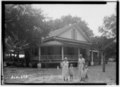
File:Historic American Buildings Survey W. N. Manning, Photographer, July 18, 1935 FRONT AND SIDE VIEW, S. E. - Crowell-Cantey-Alexander House, State Road 165, Fort Mitchell, Russell HABS ALA,57-FOMI,1-5.tif
This tag does not indicate the copyright status of the attached work. A normal copyright tag is still required. See Commons:Licensing.
Source
https://www.loc.gov/pictures/item/al0709.photos.006524p
Permission
(Reusing this file)
(Reusing this file)
| This image or media file contains material based on a work of a National Park Service employee, created as part of that person's official duties. As a work of the U.S. federal government, such work is in the public domain in the United States. See the NPS website and NPS copyright policy for more information. |
| Camera location | | View this and other nearby images on: OpenStreetMap |
|---|