Click on a date/time to view the file as it appeared at that time.
| Date/Time | Thumbnail | Dimensions | User | Comment |
|---|
| current | 21:17, 2 November 2011 |  | 1,145 × 1,432 (2.18 MB) | Inks.LWC | Cropped out labels |
| 21:09, 2 November 2011 | 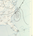 | 1,283 × 1,432 (2.37 MB) | Inks.LWC | Cropped so it's less tall |
| 19:04, 2 November 2011 |  | 1,283 × 2,068 (3.3 MB) | Inks.LWC | {{Information |Description ={{en|1=Surface analysis for July 8, 1959, specifically the area around Hurricane Cindy.}} |Source =http://docs.lib.noaa.gov/rescue/dwm/data_rescue_daily_weather_maps.html |Author =U.S. Department of Commerce, |
The following pages on the English Wikipedia use this file (pages on other projects are not listed):
The following other wikis use this file:
- Usage on pt.wikipedia.org
This file contains additional information, probably added from the digital camera or scanner used to create or digitize it.
If the file has been modified from its original state, some details may not fully reflect the modified file.


