File history
Click on a date/time to view the file as it appeared at that time.
| Date/Time | Thumbnail | Dimensions | User | Comment |
|---|
| current | 21:39, 25 December 2020 | 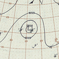 | 554 × 554 (695 KB) | Supportstorm | == {{int:filedesc}} == {{Information |Description ={{en|1=Surface weather analysis map of Hurricane Three on September 13, 1900.}} |Source =https://library.noaa.gov/Collections/Digital-Collections/Daily-Synoptic-Weather-Maps |Author =NOAA Central Library, Silver Springs, MD |Date =1900-09-13 |Permission = |other_versions = }} Category:1900 Atlantic hurricane season == {{int:license-header}} == {{PD-USGov-NOAA}} |
File usage
The following pages on the English Wikipedia use this file (pages on other projects are not listed):
This file contains additional information, probably added from the digital camera or scanner used to create or digitize it.
If the file has been modified from its original state, some details may not fully reflect the modified file.


