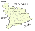
File:Hyderabad District Map 1951.svg
Click on a date/time to view the file as it appeared at that time.
| Date/Time | Thumbnail | Dimensions | User | Comment | |
|---|---|---|---|---|---|
| current | 17:19, 28 October 2015 |  | 587 × 521 (27 KB) | Furfur | Korrektur |
| 17:14, 28 October 2015 |  | 587 × 521 (27 KB) | Furfur | == {{int:filedesc}} == {{Information |Description={{de|1=Distrikteinteilung des indischen Bundesstaats Hyderabad 1951.}}{{en|1=Districts of the Indian State of Hyderabad, 1951.}} |Source=Maps of the census Bureau of India |Date=2015-10-28 |Author=[[Use... |
File usage
No pages on the English Wikipedia use this file (pages on other projects are not listed).
Global file usage
The following other wikis use this file:
- Usage on de.wikipedia.org