File:IffleyVillageMap.png
| Description |
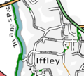
English: A map of Iffley Village in Oxford. Based on OpenStreetmap data, as of Sunday 3rd September 2006, and produced using OsmaRender |
| Date | 3 September 2006 (original upload date) |
| Source | Transferred from en.wikipedia to Commons by Stepshep using CommonsHelper. |
| Author | The original uploader was Gagravarr at English Wikipedia. |
| Permission (Reusing this file) |
This file is licensed under the Creative Commons Attribution-Share Alike 2.0 Generic license.
|

|
This city map image could be re-created using vector graphics as an SVG file. This has several advantages; see Commons:Media for cleanup for more information. If an SVG form of this image is available, please upload it and afterwards replace this template with
{{vector version available|new image name}}.
It is recommended to name the SVG file “IffleyVillageMap.svg”—then the template Vector version available (or Vva) does not need the new image name parameter. |
Licensing
| Description |
OpenStreetMap cut-out (or derivative work based on it): |
| Date | missing, probably the upload date |
| Source | OpenStreetMap project data |
| Author | OpenStreetMap contributors |
| Permission (Reusing this file) |
All OpenStreetMap data and maps are licensed under: This file is licensed under the Creative Commons Attribution-Share Alike 2.0 Generic license.
|
Original upload log
The original description page was here. All following user names refer to en.wikipedia.
- 2006-09-03 16:09 Gagravarr 504×454× (134837 bytes) A map of Iffley Village in Oxford. Based on OpenStreetmap data, as of Sunday 3rd September 2006, and produced using OsmaRender

