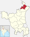
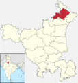
File:India - Haryana - Ambala.svg
Click on a date/time to view the file as it appeared at that time.
| Date/Time | Thumbnail | Dimensions | User | Comment | |
|---|---|---|---|---|---|
| current | 15:10, 18 March 2022 |  | 676 × 719 (1.67 MB) | C1MM | Reverted to version as of 07:44, 8 March 2022 (UTC) |
| 06:08, 18 March 2022 |  | 845 × 899 (534 KB) | C1MM | updated bounds | |
| 07:44, 8 March 2022 |  | 676 × 719 (1.67 MB) | Furfur | further details ... | |
| 07:05, 8 March 2022 |  | 676 × 719 (1.69 MB) | Furfur | graphical detail | |
| 06:57, 8 March 2022 |  | 676 × 719 (1.72 MB) | Furfur | corrected wrong district borders of Kurukshetra and some other details | |
| 05:18, 13 August 2021 |  | 845 × 899 (606 KB) | C1MM | c bounds | |
| 04:38, 26 July 2018 |  | 626 × 750 (423 KB) | Milenioscuro | corrected | |
| 12:48, 5 July 2018 |  | 579 × 611 (369 KB) | Ankit2 | Updated map with 22 districts | |
| 00:57, 6 November 2016 |  | 626 × 750 (293 KB) | Milenioscuro | User created page with UploadWizard |
File usage
The following pages on the English Wikipedia use this file (pages on other projects are not listed):
Global file usage
The following other wikis use this file:
- Usage on awa.wikipedia.org
- Usage on bh.wikipedia.org
- Usage on bn.wikipedia.org
- Usage on ca.wikipedia.org
- Usage on de.wikipedia.org
- Usage on es.wikipedia.org
- Usage on eu.wikipedia.org
- Usage on fa.wikipedia.org
- Usage on fi.wikipedia.org
- Usage on fr.wikipedia.org
- Usage on gu.wikipedia.org
- Usage on hi.wikipedia.org
- Usage on incubator.wikimedia.org
- Usage on lez.wikipedia.org
- Usage on ml.wikipedia.org
- Usage on mr.wikipedia.org
- Usage on ne.wikipedia.org
- Usage on nl.wikipedia.org
- Usage on no.wikipedia.org
- Usage on pa.wikipedia.org
- Usage on pnb.wikipedia.org
- Usage on ru.wikipedia.org
- Usage on sat.wikipedia.org
- Usage on sa.wikipedia.org
- Usage on simple.wikipedia.org
- Usage on ta.wikipedia.org
- Usage on te.wikipedia.org
- Usage on ur.wikipedia.org
- Usage on www.wikidata.org
- Usage on xmf.wikipedia.org
- Usage on zh.wikipedia.org