Loading
  • 21 Aug, 2019

  • By, Wikipedia

File:Indianapolis.svg

In some countries this may not be legally possible; if so:
SPUI grants anyone the right to use this work for any purpose, without any conditions, unless such conditions are required by law.

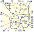
Map of numbered routes in Indianapolis, Indiana. Traced on USGS topos. Information is from the maps and photos on [1].

  • Blue: Interstate
  • Red: Current route
  • Yellow: Former route

If you need a thumbnail use Image:Indianapolis.png.

An alternate version at Image:Indianapolis numbered routes labeled.svg shows street names.
Captions

Add a one-line explanation of what this file represents

Items portrayed in this file

depicts

image/svg+xml

File history

Click on a date/time to view the file as it appeared at that time.

Date/TimeThumbnailDimensionsUserComment
current17:27, 4 June 2006Thumbnail for version as of 17:27, 4 June 20061,624 × 1,548 (723 KB)SPUI~commonswiki{{spuimap}} Map of numbered routes in Indianapolis, Indiana. Traced on USGS topos. Information is from the maps and photos on [http://illi-indi.com/IndianaHighwayList.php]. *Blue: Interstate *Red: Current route *Yellow: Former route If you need a thumbnai
The following pages on the English Wikipedia use this file (pages on other projects are not listed):

Global file usage

The following other wikis use this file: