File:International E Road Network Green.png
Click on a date/time to view the file as it appeared at that time.
| Date/Time | Thumbnail | Dimensions | User | Comment | |
|---|---|---|---|---|---|
| current | 16:09, 13 May 2008 | 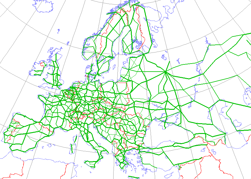 | 840 × 600 (38 KB) | Jklamo | Albania update |
| 12:07, 22 December 2007 |  | 840 × 600 (39 KB) | BIL | == Description == {{Information |Description=Map generated using coastline/boundary data from World Data Bank, and locations from www.world-gazetteer.com. Straight lines connect control cities, no attempt to follow the real road. Roads color has been chan | |
| 20:03, 7 October 2007 |  | 840 × 600 (33 KB) | The RedBurn | All e-roads in green. | |
| 19:55, 7 October 2007 |  | 840 × 600 (34 KB) | The RedBurn | {{Information |Description=Map generated using coastline/boundary data from World Data Bank, and locations from www.world-gazetteer.com. Straight lines connect control cities, no attempt to follow the real road. Roads color has been changed to green. |Sou |
File usage
More than 100 pages use this file. The following list shows the first 100 pages that use this file only. A full list is available.
- A62 autoroute
- Autopista AP-68
- Autovía A-3
- Autovía A-44
- Bundesautobahn 27
- European route E018
- European route E1
- European route E10
- European route E105
- European route E11
- European route E117
- European route E12
- European route E13
- European route E134
- European route E136
- European route E14
- European route E15
- European route E16
- European route E17
- European route E18
- European route E19
- European route E20
- European route E21
- European route E22
- European route E23
- European route E24
- European route E25
- European route E26
- European route E263
- European route E264
- European route E27
- European route E28
- European route E29
- European route E3
- European route E30
- European route E31
- European route E313
- European route E314
- European route E32
- European route E33
- European route E34
- European route E35
- European route E36
- European route E37
- European route E39
- European route E4
- European route E40
- European route E403
- European route E41
- European route E42
- European route E43
- European route E44
- European route E45
- European route E47
- European route E48
- European route E49
- European route E5
- European route E50
- European route E55
- European route E57
- European route E571
- European route E576
- European route E58
- European route E59
- European route E6
- European route E60
- European route E62
- European route E63
- European route E64
- European route E641
- European route E65
- European route E662
- European route E67
- European route E671
- European route E68
- European route E69
- European route E7
- European route E70
- European route E71
- European route E73
- European route E74
- European route E75
- European route E751
- European route E761
- European route E762
- European route E763
- European route E79
- European route E8
- European route E80
- European route E81
- European route E85
- European route E851
- European route E87
- European route E9
- European route E90
- European route E92
- European route E99
- International E-road network
- N8 road (Ireland)
- Transport in Europe
View more links to this file.
Global file usage
The following other wikis use this file:
- Usage on ar.wikipedia.org
- Usage on be.wikipedia.org
- Usage on bg.wikipedia.org
- Европейски път
- Европейски път Е79
- Европейски път Е70
- Европейски път Е80
- Европейски път Е67
- Европейски път Е85
- Европейски път Е851
- Европейски път Е671
- Шаблон:Европейска пътна мрежа
- Европейски път Е81
- Европейски път Е804
- Европейски път Е763
- Европейски път Е762
- Европейски път Е87
- Европейски път Е772
- Европейски път Е83
- Европейски път Е871
- Европейски път Е75
- Европейски път Е773
- Европейски път Е11
- Европейски път Е51
- Европейски път Е761
- Европейски път Е17
- Европейски път Е76
- Европейски път Е82
- Европейски път Е84
- Европейски път Е86
- Европейски път E01
- Европейски път E03
- Европейски път E04
- Европейски път E05
- Европейски път E06
- Европейски път E07
- Европейски път E08
- Европейски път E09
- Европейски път E10
- Европейски път E12
- Европейски път E13
- Европейски път E14
- Европейски път E15
View more global usage of this file.