Loading
  • 21 Aug, 2019

  • By, Wikipedia

File:Ireland Complete.svg

Derivative works of this file:  Ulster counties.svg

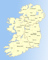
Note: the SVG code contains separate levels showing boundaries and labels for counties, historical provinces, and the modern north-south political division. The latter should not shown by default (but I notice the Wikimedia SVG renderer displays everything at once anyway). By editing the SVG, each level can be separately switched on and off.

Licensing

Public domain This work has been released into the public domain by its author, I, Future Perfect at Sunrise. This applies worldwide.
In some countries this may not be legally possible; if so:
I, Future Perfect at Sunrise grants anyone the right to use this work for any purpose, without any conditions, unless such conditions are required by law.

Captions

map of Ireland's counties and provinces

Items portrayed in this file

depicts

23 June 2007

image/svg+xml

594,789 byte

1,000 pixel

800 pixel

8335dd531e12c51d0aa0c093e5cbc37c9e77ac93

File history

Click on a date/time to view the file as it appeared at that time.

Date/TimeThumbnailDimensionsUserComment
current20:50, 8 November 2009Thumbnail for version as of 20:50, 8 November 2009800 × 1,000 (581 KB)The Illusional Ministryremoved the gradient from the water
20:49, 8 November 2009Thumbnail for version as of 20:49, 8 November 2009800 × 1,000 (580 KB)The Illusional Ministryremoved the gradient from the water.
17:06, 23 June 2007Thumbnail for version as of 17:06, 23 June 2007800 × 1,000 (581 KB)Future Perfect at Sunrise{{Information |Description= |Source=self-made |Date= |Author= Future Perfect at Sunrise }}
16:45, 23 June 2007Thumbnail for version as of 16:45, 23 June 2007800 × 1,000 (576 KB)Future Perfect at Sunrise{{Information |Description= |Source=self-made |Date= |Author= Future Perfect at Sunrise }}
16:35, 23 June 2007Thumbnail for version as of 16:35, 23 June 20072,000 × 2,500 (593 KB)Future Perfect at Sunrise{{Information |Description=SVG map of Ireland. |Source=self-made |Date=23 June 2007 |Author= Future Perfect at Sunrise }} Note: the SVG code contains separate levels showing boundaries and labels for counties, historica

The following page uses this file:

Global file usage

The following other wikis use this file: