Unless stated otherwise, UN maps are to be considered in the public domain. This applies worldwide.
Some UN maps have special copyrights, as indicated on the map itself.
UN maps are, in principle, open source material and you can use them in your work or for making your own map. UN requests however that you delete the UN name, logo and reference number upon any modification to the map. Content of your map will be your responsibility. You can state in your publication, if you wish, something like: based on UN map … (map name, map number, revision number and date). See: Geospatial Information Section. And: Geospatial, location data for a better world.
Public domainPublic domainfalsefalse
I, the copyright holder of this work, release this work into the public domain. This applies worldwide. In some countries this may not be legally possible; if so: I grant anyone the right to use this work for any purpose, without any conditions, unless such conditions are required by law.
Other versions
Original
Captions
Add a one-line explanation of what this file represents
No, this one is outdated. If i make another map, ill have to go to many different langauges wikis and replace every single map. Reverted to version as of 21:53, 26 February 2018 (UTC)
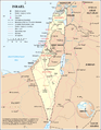
== Summary == Map of Israel, the [http://en.wikipedia.org/key/Palestinian_territories Palestinian territories] (West Bank and Gaza Strip), the Golan Heights, and neighbouring countries. Modified and adapted from http://www.un.org/Depts/Ca


 Original


