File:Italian East Africa (1938–1941).svg
[]
Date
Source
Author
Other versions
SVG development
Deutsch: Das italienische Kolonialreich (Africa Orientale Italiana) am Horn von Afrika 1936–1940.
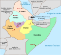
English: Italian East Africa, with provinces and provincial capitals, between May 7, 1936 (Annexation of Ethiopia) and August 1940 (when Italy invaded and annexed British Somaliland)
Español: África oriental italiana con sus provincias y capitales provinciales entre el 7 de mayo de 1936 y agosto de 1940 cuando Italia invadió y se anexionó la Somalia británica.
Français : Afrique orientale italienne, avec les provinces et les capitales de province, entre le 7 mai 1936 (annexion de l'Abbysinie) et août 1940 (invasion italienne de la Somalie britannique)
Italiano: Africa Orientale Italiana, con province e capoluoghi, tra il 7 maggio 1936 (Annessione dell'Abissinia) ed agosto 1940 (invasione italiana della Somalia britannica)
Norsk bokmål: Italiensk Øst-Afrika, med provinser og provinshovedsteder mellom 7. mai 1936 til august 1940 da britene annekterte området
Português: África Oriental Italiana (1936-1940)
Srpski (latinica): Olasz-Kelet-Afrika
Türkçe: İtalyan Doğu Afrikası 1936–1940
Русский: Административное деление ИВА после выделения провинции Шоа 7 ноября 1936 и до аннексии Британского Сомали в августе 1940.
العربية : (1936–1940) شرق أفريقيا الإيطالية
- derivative work: Themightyquill (talk)
- Italian East Africa Map.jpg: Government of Italy
- Horn of Africa and Southwest Arabia - Mid-1930s.jpg: Harriett R. Blood and Greenhorne and O'Mara prepared the maps, which were drafted by Tim Merrill and reviewed by David P. Cabitto (Library of Congress)

Catalan

English
.svg&lang=ca)
.svg&lang=en)
[]
-
 Deutsch
 -
 English
 -
 español
 -
 français
 -
 italiano
 -
 magyar
 -
 norsk
norsk -
 português
 -
 Türkçe
 -
 русский
 -
 العربية
 -
 עברית
עברית -
 中文(中国大陆)
_de.svg)
.svg)
_es.svg)
_fr.svg)
_it.svg)
-hu.svg)
_no.svg)
-pt.svg)
_tr.png)
_ru.svg)
-ar.svg)
_he.svg)
_zh-cn.svg)
.svg)
|
This SVG file contains embedded text that can be translated into your language, using any capable SVG editor, text editor or the SVG Translate tool. For more information see: About translating SVG files. |
| This is a retouched picture, which means that it has been digitally altered from its original version. The original can be viewed here: Horn of Africa and Southwest Arabia - Mid-1930s.jpg:
|
This file is licensed under the Creative Commons Attribution-Share Alike 3.0 Unported license.
- You are free:
- to share – to copy, distribute and transmit the work
- to remix – to adapt the work
- Under the following conditions:
- attribution – You must give appropriate credit, provide a link to the license, and indicate if changes were made. You may do so in any reasonable manner, but not in any way that suggests the licensor endorses you or your use.
- share alike – If you remix, transform, or build upon the material, you must distribute your contributions under the same or compatible license as the original.
Original upload log
This image is a derivative work of the following images:
- Italian East Africa Map.jpg licensed with PD-ItalyGov
- 2008-03-03T03:54:41Z Ingoman 349x336 (34163 Bytes) {{PD-ItalyGov}}
- Horn of Africa and Southwest Arabia - Mid-1930s.jpg licensed with PD-USGov
- 2008-06-16T22:32:31Z Themightyquill 503x525 (74134 Bytes) {{Information |Description={{en|1=[[Horn of Africa]] and Southwest Arabia in the mid 1930s, prior to the Italian invasion of Abyssinia}} |Source=[http://lcweb2.loc.gov/frd/cs/ethiopia/et01_04a.pdf Library of Congres, Country
Uploaded with derivativeFX


.svg)
.svg)
.svg)