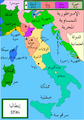
File:Italy 1796.png
A political map of Italy in early 1796, before the Napoleonic wars, created by MapMaster.
Source
Own work
Author
Capmo
Permission
(Reusing this file)
Other versions
- Bjorklund, Oddvar; Holmboe, Haakon; Rohr, Anders (1970) Historical Atlas of the World, Barnes & Noble, NY, SBN: 389-00253-4.
- Other maps, including Image:Italy 1796.jpg from the Historical Atlas by William R. Shepherd, 1926.
(Reusing this file)
I, the copyright holder of this work, hereby publish it under the following license:

|
Permission is granted to copy, distribute and/or modify this document under the terms of the GNU Free Documentation License, Version 1.2 or any later version published by the Free Software Foundation; with no Invariant Sections, no Front-Cover Texts, and no Back-Cover Texts. A copy of the license is included in the section entitled GNU Free Documentation License. |
| This file is licensed under the Creative Commons Attribution-Share Alike 3.0 Unported license. | ||
| ||
| This licensing tag was added to this file as part of the GFDL licensing update. |
[]
- Version 1
-
 SVG without labels
 -
 català (SVG)
 -
 English
 -
 français (SVG)
 -
 italiano
 -
 svenska
 -
 Ελληνικά
 -
 한국어
한국어 -
 עברית (SVG)
 -
 العربية


- Version 2
-
 català
 -
 Deutsch
 -
 English
 -
 español
 -
 italiano
 -
 magyar


- Other years, same stylesheet
-
 1000 AD
 -
 1084 AD
 -
 1494 AD
 -
 1810 AD


- Other years, similar
-
 1494
1494 -
1796
-
 1843
1843 -
 1861
1861 -
 1864
1864 -
 1870
1870


|
This historical map image could be re-created using vector graphics as an SVG file. This has several advantages; see Commons:Media for cleanup for more information. If an SVG form of this image is available, please upload it and afterwards replace this template with
{{vector version available|new image name}}.
It is recommended to name the SVG file “Italy 1796 AD.svg”—then the template Vector version available (or Vva) does not need the new image name parameter. |


