File:Jeanne-22-1945z-T50-discussion2100z.png
العربية ∙ čeština ∙ Deutsch ∙ Zazaki ∙ English ∙ español ∙ eesti ∙ suomi ∙ français ∙ hrvatski ∙ magyar ∙ italiano ∙ 日本語 ∙ 한국어 ∙ македонски ∙ മലയാളം ∙ Plattdüütsch ∙ Nederlands ∙ polski ∙ português ∙ română ∙ русский ∙ sicilianu ∙ slovenščina ∙ Türkçe ∙ Tiếng Việt ∙ 简体中文 ∙ 繁體中文 ∙ +/−

|
Summary
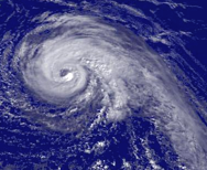
Hurricane Jeanne regional imagery, 2004.09.22 at 1945Z. Centerpoint Latitude: 26:13:30N Longitude: 70:06:12W.
Source: http://www.nnvl.noaa.gov/cgi-bin/index.cgi?page=items&ser=108310&large=1
Shortly after this image was taken the NHC quoted Dvorak T-Numbers of 5.0 from both the TAFB and SAB.
References
- ↑ NHC HURRICANE JEANNE DISCUSSION NUMBER 37.
Add a one-line explanation of what this file represents
Click on a date/time to view the file as it appeared at that time.
| Date/Time | Thumbnail | Dimensions | User | Comment |
|---|
| current | 13:12, 24 August 2006 |  | 188 × 154 (63 KB) | Tropische Storm Sven~commonswiki | ==Licensing== {{PD-USGov-DOC-NOAA}} ==Summary== Hurricane Jeanne regional imagery, 2004.09.22 at 1945Z. Centerpoint Latitude: 26:13:30N Longitude: 70:06:12W. Source: http://www.nnvl.noaa.gov/cgi-bin/index.cgi?page=items&ser=108310&large=1 Shortly after |
The following 3 pages use this file:
The following other wikis use this file:
- Usage on ca.wikipedia.org
- Usage on de.wikipedia.org
- Usage on es.wikipedia.org
- Usage on fr.wikipedia.org
- Usage on ja.wikipedia.org
- Usage on nl.wikipedia.org
- Usage on pt.wikipedia.org
- Usage on zh.wikipedia.org