Click on a date/time to view the file as it appeared at that time.
| Date/Time | Thumbnail | Dimensions | User | Comment |
|---|
| current | 21:18, 19 June 2015 | 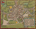 | 2,497 × 2,018 (1.5 MB) | Joop Rotte | Resolutie geoptimaliseerd en 'A - Sainte Giles' zichtbaar gemaakt door de Legenda iets te verkleinen & te verplaatsen |
| 16:31, 19 June 2015 | 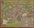 | 2,052 × 1,674 (1.17 MB) | Joop Rotte | Leukere kleurtjes, hogere resolutie en een legenda bijgeplakt, bron [http://cudl.lib.cam.ac.uk/view/PR-ATLAS-00002-00061-00001/33 University of Cambridge] |
| 08:02, 15 August 2005 | 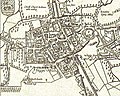 | 597 × 476 (159 KB) | ¡0-8-15! | John Speed's map of Oxford, 1605. North is at the bottom. Oxford is still a walled city, but there some buildings are outside the walls, including Magdalen College. "P" is Oxford Castle. "N" is Oxford's central crossroads at the junction of the High S |
The following pages on the English Wikipedia use this file (pages on other projects are not listed):
The following other wikis use this file:
- Usage on ar.wikipedia.org
- Usage on ast.wikipedia.org
- Usage on bg.wikipedia.org
- Usage on ca.wikipedia.org
- Usage on cs.wikipedia.org
- Usage on de.wikipedia.org
- Usage on el.wikipedia.org
- Usage on eo.wikipedia.org
- Usage on es.wikipedia.org
- Usage on fr.wikipedia.org
- Usage on fy.wikipedia.org
- Usage on gu.wikipedia.org
- Usage on he.wikipedia.org
- Usage on hu.wikipedia.org
- Usage on id.wikipedia.org
- Usage on it.wikipedia.org
- Usage on ja.wikipedia.org
- Usage on la.wikipedia.org
- Usage on nn.wikipedia.org
- Usage on pl.wikipedia.org
- Usage on ru.wikipedia.org
- Usage on sl.wikipedia.org
- Usage on th.wikipedia.org
- Usage on tr.wikipedia.org
- Usage on uk.wikipedia.org
- Usage on vi.wikipedia.org
- Usage on zh.wikipedia.org
This file contains additional information, probably added from the digital camera or scanner used to create or digitize it.
If the file has been modified from its original state, some details may not fully reflect the modified file.
 You must also include a United States public domain tag to indicate why this work is in the public domain in the United States.


