File:Jomann Imperium Periscum.jpg
Copperplate print on paper, colorized, 53 × 60.7 cm
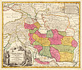
Detailed map of the Persian empire, extending from the Black Sea, Khasikstan and Turkistan in the North to the Red Sea, Persian Gulf, Euphrates and the Mediterranean in the South, showing a part of Cyprus. Decorative map, showing cities, mountains, rivers, lakes, roads, etc. Large decorative cartouche inthe lower left corner and smaller cartouche in the right upper corner
Detailed map of the Persian empire, extending from the Black Sea, Khasikstan and Turkistan in the North to the Red Sea, Persian Gulf, Euphrates and the Mediterranean in the South, showing a part of Cyprus. Decorative map, showing cities, mountains, rivers, lakes, roads, etc. Large decorative cartouche inthe lower left corner and smaller cartouche in the right upper corner
| Johann Homann
(1664–1724) |
|||
|---|---|---|---|
 |
|||
| Alternative names |
Johann Baptist Homann; Ioannis Baptista Homann; Johann-Baptista Homann; Johann Baptista Homann | ||
| Description | German cartographer, publisher and copperplate engraver | ||
| Date of birth/death |
20 March 1664 |
1 July 1724 | |
| Location of birth/death |
Kammlach |
Nuremberg | |
| Work location | |||
| Authority file | |||


