Click on a date/time to view the file as it appeared at that time.
| Date/Time | Thumbnail | Dimensions | User | Comment |
|---|
| current | 23:54, 23 August 2012 | 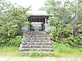 | 3,264 × 2,448 (1.74 MB) | Miyuki Meinaka | New!! |
| 01:42, 7 April 2009 | 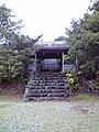 | 960 × 1,280 (451 KB) | Miyuki Meinaka | {{Information |Description={{en|1=This is a shinto shrine in Kashikojima,Shima,Mie,Japan.}} {{ja|1=三重県志摩市阿児町神明賢島にある、金刀比羅宮(金毘羅宮)の画像。}} |Source=Own work by uploader |Author=[[User:Miyuki Meinak |
The following page uses this file:
The following other wikis use this file:
- Usage on ja.wikipedia.org

