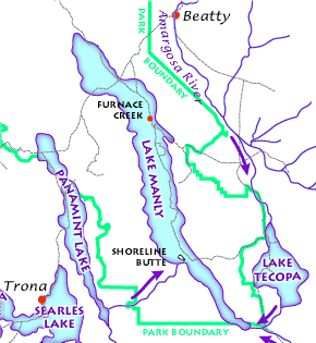
File:Lake Manly System.png
Death Valley Geology Field Trip: Shoreline Butte:
Permission
(Reusing this file)
Geotemporal data
Bounding box
Georeferencing
Other versions
- http://www.nature.nps.gov/geology/usgsnps/deva/ftsho1.html
- http://www.nature.nps.gov/geology/usgsnps/deva/lakemanly.gif
(Reusing this file)
| This image or media file contains material based on a work of a National Park Service employee, created as part of that person's official duties. As a work of the U.S. federal government, such work is in the public domain in the United States. See the NPS website and NPS copyright policy for more information. |
| N: 36.9982467°N | ||
| W: 117.6506682°W | E: 116.0117759°W | |
| S: 35.5805546°N | ||

|
This map image could be re-created using vector graphics as an SVG file. This has several advantages; see Commons:Media for cleanup for more information. If an SVG form of this image is available, please upload it and afterwards replace this template with
{{vector version available|new image name}}.
It is recommended to name the SVG file “Lake Manly system.svg”—then the template Vector version available (or Vva) does not need the new image name parameter. |
