Click on a date/time to view the file as it appeared at that time.
| Date/Time | Thumbnail | Dimensions | User | Comment |
|---|
| current | 11:50, 4 February 2011 | 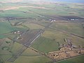 | 640 × 480 (70 KB) | GeographBot | == {{int:filedesc}} == {{Information |description={{en|1=Longside Airfield Taken G-BSOZ 17th Dec 06.}} |date=2006-12-17 |source=From [http://www.geograph.org.uk/photo/442319 geograph.org.uk] |author=[http://www.geograph.org.uk/profile/14644 Alan Stewart] |
The following page uses this file:
This file contains additional information, probably added from the digital camera or scanner used to create or digitize it.
If the file has been modified from its original state, some details may not fully reflect the modified file.
