Click on a date/time to view the file as it appeared at that time.
| Date/Time | Thumbnail | Dimensions | User | Comment |
|---|
| current | 23:56, 5 February 2011 | 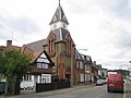 | 640 × 480 (71 KB) | GeographBot | == {{int:filedesc}} == {{Information |description={{en|1=Loughton: Lopping Hall Lopping Hall was opened in 1884 and was paid for by The Corporation of London to compensate the villagers of Loughton for the loss of their traditional rights to lop trees in |
The following pages on the English Wikipedia use this file (pages on other projects are not listed):
The following other wikis use this file:
- Usage on fa.wikipedia.org
- Usage on fr.wikipedia.org
- Usage on lv.wikipedia.org
- Usage on nl.wikipedia.org
- Usage on www.wikidata.org
This file contains additional information, probably added from the digital camera or scanner used to create or digitize it.
If the file has been modified from its original state, some details may not fully reflect the modified file.
